- Reliable Slide Switches? - 3 Updates
- Starting problem with a Samsung Lappy - 1 Update
- What does decent celestial navigation freeware on Android actually do? - 9 Updates
- capacitance meter - 1 Update
| Jon Elson <elson@pico-systems.com>: Nov 26 11:49PM -0600 Allodoxaphobia wrote: >> Are there other brands I should consider trying, or do people >> think I just got ones from a bad batch? > I've always felt that "Reliable Slide Switch" was an oxymoron. Yes, I'm with you. I have seen some very special switches that had a slider or rocker that operated a microswitch with a cam-like mechanism. These were probably for aerospace reliability level applications, and prices accordingly. The typical slide switches have really mediocre contacts with thin plating, and once the springy contact fingers had worn down, you'd get poor contact, base metal on base metal. Jon |
| "Ron D." <Ron.Dozier@gmail.com>: Nov 27 11:58AM -0800 Check out http://ceilingfanparts.com/images/pullchainsw.htm (RVSS6) You may have to verify that they are threaded. It's been a while since I ordered that part. The switchcraft 46206 series doesn't have threads. You can also use two of these speed nuts: http://www.marshallshardware.com/products/productList.aspx?uid=2-411-246-228 Too bad this place doesn't give dimensions. Here's https://www.mcmaster.com/#speed-nuts/=1584m2a a place that does. |
| Tim R <timothy42b@aol.com>: Nov 28 05:40AM -0800 Just a random thought. I had a small single bulb floor lamp I used over a music stand. The switch was inline with the cord, not a slide switch but a thumb wheel type. I put a CFL in it. I got arcing when switching and the switch didn't always work. I had to go back to an incandescent. My take was that the electronics in the CFL were too much for a maybe marginal switch. These run at a power factor less than 0.6. Anyway it worked fine with an incandescent. And yet, now I have an LED in it and that also works fine. |
| "Lund-Nielsen, Jorgen" <jorgen.lund-nielsen@xyz123desy.de>: Nov 28 09:26AM +0100 Am 24.11.2016 um 12:13 schrieb N_Cook: >> running when cold. >> Jon > summarised as crappy cappy in lappy user not happy J |
| Jeff Liebermann <jeffl@cruzio.com>: Nov 27 10:09AM -0800 On Sun, 27 Nov 2016 16:01:33 +0000 (UTC), Raymond Spruance III >Do you know anything about celestial navigation? Yep. >to learn how it's done (in case I ever need it in an emergency) and to show >a high school math teacher how its done so she can use it to make trig more >interesting to her students. You're unlikely to have a working Android device available in an emergency. At best, a WWV/WWVB receiver, reasonable accurate clock, and HO229 sight reduction tables or this years nautical almanac. If you're going to impress a math teacher, then *YOU* get to do the required math, not the computah. The only thing the computah does is replace the tables and save you from the pain of interpolation. You still have to do 3 other sextant sight corrections (index error, dip, altitude correction). You can download HO229 or the nautical almanac from: <http://thenauticalalmanac.com> There are plenty of instructional videos on YouTube under "how to use a sextant" and such. Most deal with a noon sight, which is where you start. Since you're likely to be doing this on land, instead of at sea, you'll need an artificial horizon for your sextant. <http://www.davisnet.com/product/artificial-horizon/> The rest is RTFM, arithmetic, and practice. Once you've mastered the noon sight, try using the moon or stars. If you want a lesson in reality, find a suitable sailboat, wrap one arm around the mast, and then try taking a series of noon sights. >All I ask in this thread are the basic questions anyone new to celestial >navigation would ask: >a. What freeware is the best one to try out first? The free Nautical Almanac. It's in PDF form so you can display it on a laptop, eBook reader, or whatever while you do the math by hand. >b. What are the minimum required features of that freeware Ummm... that it's free? If you want to learn navigation, you're going to need to learn about celestial mechanics, navigational conventions, a fair number of new terms, and what happens when you're in a different part of the planet. You could learn those from a computah program that offers a tutorial, but I believe these are best learned with paper and pen. Once you're proficient with the process, then you can use the computer to allegedly save you some time. Good luck and have fun. -- Jeff Liebermann jeffl@cruzio.com 150 Felker St #D http://www.LearnByDestroying.com Santa Cruz CA 95060 http://802.11junk.com Skype: JeffLiebermann AE6KS 831-336-2558 |
| Raymond Spruance III <spruancerayIII@example.com>: Nov 27 06:54PM On Sun, 27 Nov 2016 10:09:46 -0800, Jeff Liebermann wrote: > You're unlikely to have a working Android device available in an > emergency. You're right Jeff, but one nice thing about knowledge is that you have *that* always with you, even in an emergency. So, one goal, always, is to *learn* how to do celestial navigation, where, in a pinch, you can approximate given the experience gained using the battery operated tools. > At best, a WWV/WWVB receiver, reasonable accurate clock, > and HO229 sight reduction tables or this years nautical almanac. Really on the accurate clock? C'mon. I'll bet a five-dollar digital watch has better accuracy than all the navigators had in the age of exploration. > If > you're going to impress a math teacher, then *YOU* get to do the > required math, not the computah. Yes. Indeed. But I would like the help of the instruments and the calculations, since, half of math is just intuition on how to do it (which is gained by being right before, when you have more tools available). > The only thing the computah does is > replace the tables and save you from the pain of interpolation. Fine with me. > You > still have to do 3 other sextant sight corrections (index error, dip, > altitude correction). Can a plastic protractor substitute for a sextant for our purposes? (i.e., it's more the process than the accuracy that I'm after.) > You can download HO229 or the nautical almanac from: > <http://thenauticalalmanac.com> Egads. 250 pages. For 2016 only! Another 250 pages for 2017. Plus 180 Megabytes of celestial stuff. Wow. There's a *lot* of learning that needs to be accomplished. I thought it was just a sighting of about 60 stars! > There are plenty of instructional videos on YouTube under "how to use > a sextant" and such. Most deal with a noon sight, which is where you > start. Ah, Jeff. Thanks for letting me know where you sight. Seems to me a "noon sighting" is easy. stick a twig in the ground, mark when the shadow switches from west to east, and bingo. That's noon at your longitude when compared with GMT, and, voila! I guess a noon longitude is as simple, using a rough estimate of the angle from the horizon to the sun. Bingo. Latitude. > Since you're likely to be doing this on land, instead of at > sea, you'll need an artificial horizon for your sextant. > <http://www.davisnet.com/product/artificial-horizon/> Interesting. A $32 artificial horizon. Who knew that's needed? Seems to me a bubble meter should work as well. Right? Can't the phone bubble meter work for an artificial horizon? Anyway, you are correct these are land sightings. In mountains. Santa Cruz mountains. > noon sight, try using the moon or stars. If you want a lesson in > reality, find a suitable sailboat, wrap one arm around the mast, and > then try taking a series of noon sights. Thanks for the suggestion of starting with a noon sight, and then a moon sight (must be a sailor's rhyme there somewhere). And yes, I get seasick, so, I'm intimately familiar with the reality of the motion of the ocean (I give Captain William Bligh a lot of credit for what he done did). >>a. What freeware is the best one to try out first? > The free Nautical Almanac. It's in PDF form so you can display it on > a laptop, eBook reader, or whatever while you do the math by hand. Very interesting that this PDF is all that is needed (along with a sextant and an artificial horizon, both of which should be phone tools if you ask me). 2017: https://thenauticalalmanac.com/2017%20Nautical%20Almanac.pdf 2016: https://thenauticalalmanac.com/2016%20Nautical%20Almanac.pdf > to need to learn about celestial mechanics, navigational conventions, > a fair number of new terms, and what happens when you're in a > different part of the planet. For now, Jeff, I'm gonna be at around 35 to 40 degrees North and about 120 to 122 degrees West. After I get good at that, I can work on the other angles. > program that offers a tutorial, but I believe these are best learned > with paper and pen. Once you're proficient with the process, then you > can use the computer to allegedly save you some time. Thanks for the advice. What would be nice is learning how to do dead reckoning with the phone as the artificial horizon and sextant and a few well-known start (e.g., Polaris) as the frame of reference. |
| Harkung Vorbestellung <harkung@harkung.com>: Nov 27 07:13PM On Sun, 27 Nov 2016 18:54:08 -0000 (UTC), Raymond Spruance III wrote: > Can a plastic protractor substitute for a sextant for our purposes? Here are PDF almanacs: http://thenauticalalmanac.com Tools needed should all be on Android for free: a. sextant (tutorial https://www.youtube.com/watch?v=qsErtrttJsY) b. artificial horizon (tutorial https://www.youtube.com/watch?v=B5Ud9iPW-yk) c. almanac (tutorial https://www.youtube.com/watch?v=p6znyx0gjb4 For example: A. Android Sextant App by Talltree Software: https://play.google.com/store/apps/details?id=com.sharpitor.nightsky20 B. Aircraft Horizon Free by Sensorworks https://play.google.com/store/apps/details?id=com.sensorworks.aircrafthorizon_free C. Google Sky Map: https://play.google.com/store/apps/details?id=com.google.android.stardroid |
| MJC <gravity@mjcoon.plus.com>: Nov 27 09:41PM In article <o1fa4f$fg3$1@news.mixmin.net>, spruancerayIII@example.com says... > Really on the accurate clock? C'mon. I'll bet a five-dollar digital watch > has better accuracy than all the navigators had in the age of exploration. But explorers, by definition, don't need to know exactly where they are because they don't have accurate charts anyway! Not to mention a lot of them came to grief... Mike. |
| James Mick <JamesMick4499@yahoo.com>: Nov 27 10:33PM MJC wrote: > But explorers, by definition, don't need to know exactly where they are > because they don't have accurate charts anyway! Not to mention a lot of > them came to grief... The early explorers used plenty of charts and tables though! Peter Hakel has made many spreadsheets for Celnav that are useful. http://www.navigation-spreadsheets.com/navigation_triangles.html A perfect Sun sight reduction spreadsheet can be obtained here. http://backbearing.com/excel.html Erik Deman has all of the Nautical Almanac information on his site. http://www.siranah.de/ You can get HO 249 Volumes 1, 2 and 3 here; https://www.celestaire.com/pubs/category/3-pub-249.html Fair winds and clear skies. |
| Jeff Liebermann <jeffl@cruzio.com>: Nov 27 02:40PM -0800 On Sun, 27 Nov 2016 18:54:08 -0000 (UTC), Raymond Spruance III >> emergency. >You're right Jeff, but one nice thing about knowledge is that you have >*that* always with you, even in an emergency. I'm not sure what manner of emergency would require knowing your exact location using a sextant, but I would guess(tm) that it's either nautical or aeronautical. Somehow, I don't see you tramping around the woods with a sextant. If you're on land, can see some landmarks, and have a map, you don't need a sextant. Therefore, unless you're planning to go sailing or flying, a sextant isn't going to be much help, even with an Android phone (which has a GPS receiver). >So, one goal, always, is to *learn* how to do celestial navigation, where, >in a pinch, you can approximate given the experience gained using the >battery operated tools. Ok, a hybrid approach. I'm more of a purist, but that's fine. As I mumbled, all that an Android app buys you is a laundry list of boxes to fill with numbers, a scratch pad, and if the program is really good, a sanity check. >> and HO229 sight reduction tables or this years nautical almanac. >Really on the accurate clock? C'mon. I'll bet a five-dollar digital watch >has better accuracy than all the navigators had in the age of exploration. I'll take the bet. First, you only need an accurate clock if you want to obtain your latitude. Longitude can be done with just a noon sight. Latitude requires a clock. Find yourself a copy of "Longitude: The True Story of a Lone Genius Who Solved the Greatest Scientific Problem of His Time" <https://en.wikipedia.org/wiki/Longitude_(book)> There are also some YouTube videos on the topic of Longitude: <https://www.youtube.com/watch?v=ecrf8KhVcyo> (3hrs) <https://www.youtube.com/watch?v=NENPdT4LASw> (54 min Nova version) There's quite a bit there on how navigation was done in the 18th century including the accuracy of the various John Harrison clocks. "John Harrison's 'longitude' clock sets new record - 300 years on" <http://www.independent.co.uk/news/science/john-harrisons-longitude-clock-sets-new-record-300-years-on-10187304.html> One second in 100 days (on land). The target value for an acceptable clock was 1 minute in 50 days. I don't want to get into a rant on the accuracy of todays digital watches. Everything is dependent on the stability of the tuning for crystal, with is far from temperature stable. I just dug out the specs for a random Casio wristwatch. About +/-12 sec per month at room temp and who knows over a reasonable temperature range. I'm sure someone has done some testing, but I'm late for a free lunch, so you get to Google for the numbers. >Can a plastic protractor substitute for a sextant for our purposes? >(i.e., it's more the process than the accuracy that I'm after.) No, unless you're only interested in knowing which state you're in. Also, the optics one a sextant are designed to protect your eyes. Prior to the sextant, the use of a cross staff required staring at the sun, a really bad idea. >> <http://thenauticalalmanac.com> >Egads. 250 pages. For 2016 only! Another 250 pages for 2017. >Plus 180 Megabytes of celestial stuff. You're not expected to read it cover to cover. On the average, you'll use 3 or 4 pages at a time. However, for every sighting, all 3 or 4 pages are different. >Wow. There's a *lot* of learning that needs to be accomplished. >I thought it was just a sighting of about 60 stars! Stop complaining and start reading. >> sea, you'll need an artificial horizon for your sextant. >> <http://www.davisnet.com/product/artificial-horizon/> >Interesting. A $32 artificial horizon. Who knew that's needed? You can build your own: <https://thenauticalalmanac.com/Artificial%20Horizon.html> >Seems to me a bubble meter should work as well. Right? >Can't the phone bubble meter work for an artificial horizon? Neither is accurate. Bolting a bubble level onto the sextant is that way its done on aeronautical sextants as the sloshing of the liquid in the larger reflection type artificial horizon doesn't work well on a vibrating airplane. >Thanks for the suggestion of starting with a noon sight, and then a moon >sight The moon is tricky. It moves quite rapidly across the field of vision and is therefore difficult to get an accurate measurement. >Thanks for the advice. What would be nice is learning how to do dead >reckoning with the phone as the artificial horizon and sextant and a few >well-known start (e.g., Polaris) as the frame of reference. I can tell this is not going to be a classical lesson in navigation. No, you can't borrow any of my sextants. -- Jeff Liebermann jeffl@cruzio.com 150 Felker St #D http://www.LearnByDestroying.com Santa Cruz CA 95060 http://802.11junk.com Skype: JeffLiebermann AE6KS 831-336-2558 |
| Robert Bannon <rbannon@yahoo.spam.nowhere.invalid>: Nov 27 10:56PM On 27 Nov Allodoxaphobia scrit: > And you _just had_ to cross-post this to sci.electronics.repair Too bad it wasn't cross posted to the windows ng. They could use this information below. 1. TeaCup http://www.teacupnavigation.net/CN.html 2. StarCalc http://www.relex.ru/~zalex/main.htm 3. SeaClear http://www.sping.com/seaclear/ 1. Teacup Navigation has free celestial software and a free book in PDF format for downloading. The book teaches the concepts and techniques of celestial navigation, some interesting history, and computational methods using a simple pocket scientific calculator. The book also has condensed tables and work sheets for when you have no calculators available. It also shows how to build your own navigational tools. The free comprehensive celestial navigation software is for the Windows operating system. It will run in Ubuntu (Linux) when "Wine" software is also installed. The same is true for a Mac when the Mac version of Wine is used. The Teacup Navigation site is at http://www.teacupnavigation.net/CN.html 2. StarCalc is a free program that will bring a planetarium onto your computer monitor. The program is a creation of Alexander E. Zavalishin, a Russian, and is provided at no charge. This program will show a picture of the sky at any time of the day or night from any location in the world at any time. The program provides an alternative to the "Star Finder" plastic circular slide rule used in the JN and N courses. Using the program, you can print a copy of the sky showing the bodies that you intend to "shoot". The graphic provided by StarCalc gives a clear diagram of where the celestial targets of opportunity are located and the hassle of plotting solar system objects is eliminated. The StarCalc program can be downloaded from: http://www.relex.ru/~zalex/main.htm 3. SeaClear is a freeware navigation program for Windows NT 4.0, 2000 or 95/98/ME which, when connected to a GPS (or other unit capable of transmitting NMEA position data), will display the vessel on a chart, with the current position, speed and direction. New charts are loaded as needed. The track may be saved to a file for later reviewing, and log book entries may be manually and automatically entered. An unlimited number of routes and waypoints may be created and used to assist in the navigation. The screen area for charts is maximized with most functions accessed with the right mouse button. Zooming is provided with support for IntelliMouse wheel. The program may be downloaded from: http://www.sping.com/seaclear/ |
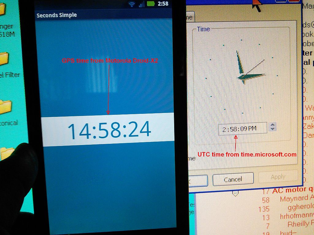
| Jeff Liebermann <jeffl@cruzio.com>: Nov 27 05:27PM -0800 On Sun, 27 Nov 2016 14:40:54 -0800, Jeff Liebermann <jeffl@cruzio.com> wrote: >I'll take the bet. First, you only need an accurate clock if you want >to obtain your latitude. Longitude can be done with just a noon >sight. Latitude requires a clock. Sigh. No brain today. That should be Latitude can be done with a noon sight while longitude requires a clock. Dyslexia induced by schlepping a 150 lb drill press up about 40 stairs. >room temp and who knows over a reasonable temperature range. I'm sure >someone has done some testing, but I'm late for a free lunch, so you >get to Google for the numbers. For a common digital clock: <https://en.wikipedia.org/wiki/Quartz_clock#Accuracy> "...a typical quartz clock or wristwatch will gain or lose 15 seconds per 30 days (within a normal temperature range of 5 °C/41 °F to 35 °C/95 °F) or less than a half second clock drift per day when worn near the body." or a marine chronometer: <https://en.wikipedia.org/wiki/Marine_chronometer#Today> "...even in wrist watches such as the Omega Marine Chronometer, that are accurate to within 5 or 20 seconds per year." Incidentally, be careful what you use for a clock. GPS time is currently 17 seconds ahead of UTC (WWV/WWVB) time: <http://www.leapsecond.com/java/gpsclock.htm> For navigation, you want GMT, UTC or UT1 (all the same). Most GPS receivers and smartphones correct for this, but not every smartphone manufacturer got the memo: <http://802.11junk.com/jeffl/crud/GPS-vs-UTC.jpg> Best to check your smartphone: 60 nautical miles = 1 degree of latitude 1 nautical mile = 6076ft 60 NM/sec * 6076ft/NM / 3600 sec/deg= 101 ft/second Therefore the 17 second difference between GMT and UTC will produce an error of about 1,717 ft (about 1/4th nautical mile) in longitude at the equator and lesser errors at higher latitudes. -- Jeff Liebermann jeffl@cruzio.com 150 Felker St #D http://www.LearnByDestroying.com Santa Cruz CA 95060 http://802.11junk.com Skype: JeffLiebermann AE6KS 831-336-2558 |
| Raymond Spruance III <spruancerayIII@example.com>: Nov 28 04:05AM On Sun, 27 Nov 2016 17:27:31 -0800, Jeff Liebermann wrote: > Sigh. No brain today. That should be Latitude can be done with a > noon sight while longitude requires a clock. Dyslexia induced by > schlepping a 150 lb drill press up about 40 stairs. You had me scared, Jeff, when you flipped the coordinate system on me. I'm currently reading this book, so hopefully I'll be slightly more educumated when I next write back. Celestial Navigation in a Teacup, by Rodger E. Farley http://www.teacupnavigation.net/Celestial_Navigation_in_a_Teacup_v.pdf The goal is to give the math teacher a lesson for her high school kids, using freeware, where most are on iOS but some are on Android. |
| Bob Engelhardt <BobEngelhardt@comcast.net>: Nov 27 09:27PM -0500 On 11/6/2016 3:43 PM, Bob Engelhardt wrote: > Can anybody help? > Thanks, > Bob I asked this of a number of eBay sellers with the same meter. 2 answered - one said that he'd ask his supplier & the other that he thought it was because the manufacturer used the same case for another meter. That explains the 3 sockets, but not the labeling. Oh well. Maybe I'll open it. Someday. Bob |
| You received this digest because you're subscribed to updates for this group. You can change your settings on the group membership page. To unsubscribe from this group and stop receiving emails from it send an email to sci.electronics.repair+unsubscribe@googlegroups.com. |
No Response to "Digest for sci.electronics.repair@googlegroups.com - 14 updates in 4 topics"
Post a Comment