- OT How does GMaps know elevation? - 17 Updates
| micky <NONONOmisc07@bigfoot.com>: Jul 30 02:43PM -0400 When you use google maps to choose a route between two locations, and choose walking or bicycling, it also shows starting and ending elevation and a graph that shows changes, so you can see how many and how big the hills are. Also useful, of course, just for finding elevation without any walking. But how does it know elevation. If a GPS gets signals from 3 satellites, it can calculate location, and if it gets signals from 4 of them, it can calculate elevation. But the calculation is made in the GPS device, such as a smartphone. Google doesn't have GPS devices at any random location the user picks, and it has no way to read satellite signals. Is there some topographical map underlying the google maps, even though there is no way to display that map wwithin google? |
| Jeff Urban <jurb6006@gmail.com>: Jul 30 11:46AM -0700 Satellite. |
| N_Cook <diverse@tcp.co.uk>: Jul 30 08:04PM +0100 On 30/07/2019 19:43, micky wrote: > signals. > Is there some topographical map underlying the google maps, even though > there is no way to display that map wwithin google? Check out a convenient Google height and you'll find its a load of junk. In the UK luckily there are still a lot of surviving Ordnance Survey benchmarks around and you can optically survey to them and easily get to mm accurace if no more than 1-200m away (wrt the old map data containing benchmark heights). It is possible of course that the underlying land has risen or fallen from post glacial isostatic rebound or water/oil extraction etc. But even with mobile phone link dGPS (aGPS) surveying the resolution/repeatability is no better than 15mm. And can easily be a lot worse and without a second method (eg benchmarks) you won't know. Outside the UK I've no idea if there are other networks of benchmarks. I would like to find an "ap" where , as the GPS orbits are known , that it would be possible to find times in the near future where 4 satellites would be near enough overhead and none at lower elevation. I wonder what sort of height determination you could get with that for height determination. -- Monthly public talks on science topics, Hampshire , England <http://diverse.4mg.com/scicaf.htm> |
| Andy Burns <usenet@andyburns.uk>: Jul 30 08:06PM +0100 micky wrote: > Google doesn't have GPS devices at > any random location the user picks Every user carrying a GPS enabled android device is crowd-sourcing data for google, if someone's been there, google will know the altitude. |
| "\"Retired"@home.com: Jul 30 03:24PM -0400 On 7/30/19 2:43 PM, micky wrote: > Is there some topographical map underlying the google maps, even though > there is no way to display that map wwithin google? If you click on the GMaps Menu icon (3 line "hamburger" on top left) there is a choice called "Terrain" While not a true USGS topo map, you get the idea. |
| scott@slp53.sl.home (Scott Lurndal): Jul 30 08:19PM >> any random location the user picks >Every user carrying a GPS enabled android device is crowd-sourcing data >for google, if someone's been there, google will know the altitude. Nonsense. |
| Bennett <bjprice@cal.berkeley.edu>: Jul 30 03:48PM -0700 On 7/30/2019 11:43 AM, micky wrote: > signals. > Is there some topographical map underlying the google maps, even though > there is no way to display that map wwithin google? Just a guess that Google Maps could use elevation data from Google Earth, (or its sources), which, according to this paper from 2017, makes GE generally accurate: https://journals.plos.org/plosone/article?id=10.1371/journal.pone.0175756 Apparently there are lots of accurate sources for elevation data. |
| micky <NONONOmisc07@bigfoot.com>: Jul 30 07:02PM -0400 In alt.home.repair, on Tue, 30 Jul 2019 20:19:06 GMT, >>> any random location the user picks >>Every user carrying a GPS enabled android device is crowd-sourcing data >>for google, if someone's been there, google will know the altitude. That's a thought. >Nonsense. That's a thought, too! BTW, I tried to use google walking to see how much elevation change there was to the top of the next hill. I had thought the top of the hill was the big street nearby, going along a crest (although crest sounds more like a mountain than a hill.) I found out, if it's at all correct, that's it's about halfway between that big street and the next one aand that my elevation is about 400 feet. Typically, google directions gives three routes, and when I changed to one of the others, it changed my elevation to 403 feet, even though it was the same place. It turns out I'm about 65 feet below the top of the ridge of hills a half mile away. I think I don't get as much breeze as I would if I were higher up. I'm not sure because I can't be in two places at once and I spend comparitively little time farther up the hill. I like living next to a stream, but not getting much breeze seems to be the other side of the coin. Does it seem correct to you that a mere 65' valley would be enough to lessen the breeze I get? |
| micky <NONONOmisc07@bigfoot.com>: Jul 30 07:17PM -0400 In alt.home.repair, on Tue, 30 Jul 2019 15:24:37 -0400, >If you click on the GMaps Menu icon (3 line "hamburger" on top left) >there is a choice called "Terrain" >While not a true USGS topo map, you get the idea. Wow. I saw that years ago but I guess I forgot. And that was just what I meant, a topographical map already ;inked to to the street map. I guess that answers the question. Gfretwell said: >My guess is the Google Car that shoots all of the street view pictures >is using GPS to link the pictures to the map and they get the >elevation data at the same time. That would make sense, and would be a lot easier than a lot of the things they do. Did you all know that besides the Google Car, there is now the Google Man, who wears the camera a couple feet above his head, and they have streetview pictures of some places one can only walk. I think once I saw google pictures from a bicycle. Thanks, all. |
| rbowman <bowman@montana.com>: Jul 30 07:04PM -0600 On 07/30/2019 12:43 PM, micky wrote: > GPS device, such as a smartphone. Google doesn't have GPS devices at > any random location the user picks, and it has no way to read satellite > signals Probably LIDAR. https://gisgeography.com/dem-dsm-dtm-differences/ https://gizmodo.com/google-has-its-own-fleet-of-airplanes-to-map-the-world-5916290 The gizmodo article talks about photographing for the 3D imagery but while you're flying around might as well get the LIDAR data too. |
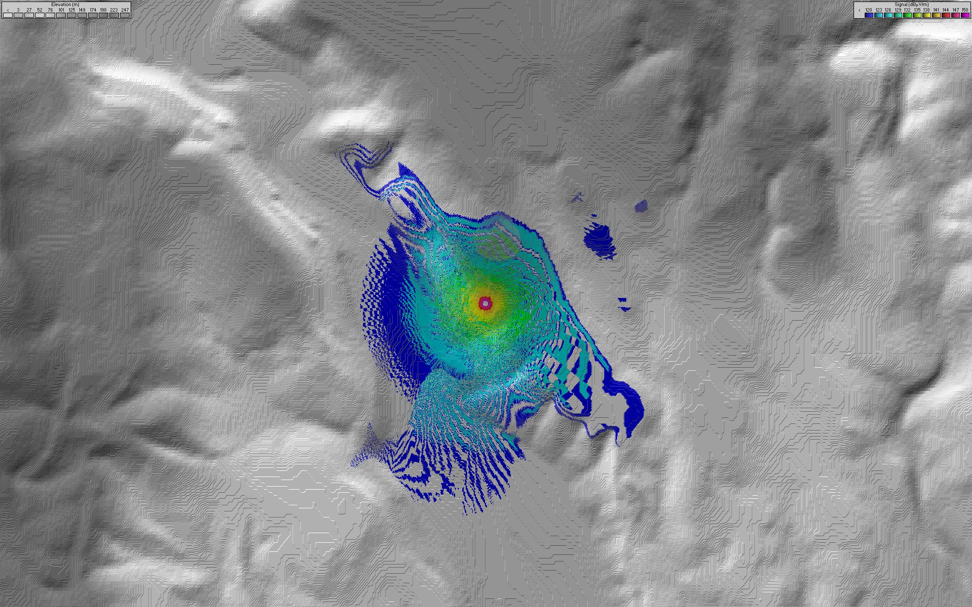
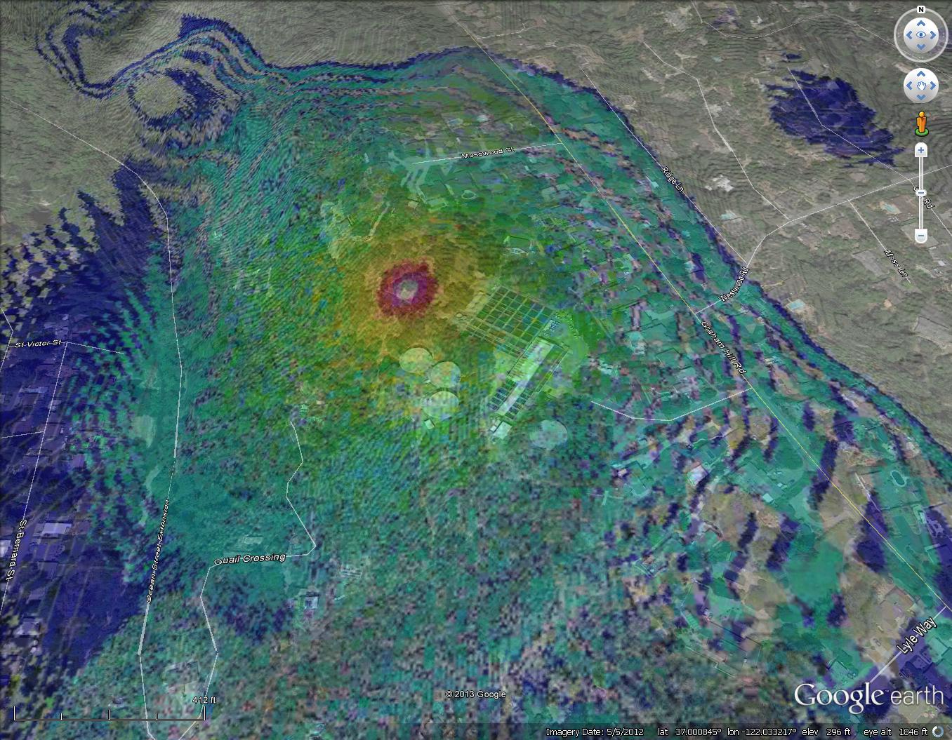
| Jeff Liebermann <jeffl@cruzio.com>: Jul 30 09:41PM -0700 >If you click on the GMaps Menu icon (3 line "hamburger" on top left) >there is a choice called "Terrain" >While not a true USGS topo map, you get the idea. Yep. The basic numbers come from various elevation and terrain models and databases. For example: <https://www.usgs.gov/faqs/where-can-i-get-elevation-data?qt-news_science_products=7#qt-news_science_products> <https://www.usgs.gov/core-science-systems/ngp/3dep/about-3dep-products-services> <http://vterrain.org/Elevation/global.html> <https://gisgeography.com/free-global-dem-data-sources/> etc. There are ground level elevation maps, maps that include tree and building heights for urban radio propagation studies, and maps that include ocean bottom depths instead of ocean surface. There's even a database of elevation databases: <https://catalog.data.gov/dataset?tags=elevation> For radio propagation studies, I use Radio Mobile software: <http://www.ve2dbe.com/english1.html> and SRTM (shuttle radar topography mission) 1 arc second (30 meter) maps: <https://www2.jpl.nasa.gov/srtm/> I usually take the Radio Mobile maps, which show elevation, <http://www.learnbydestroying.com/jeffl/coverage/VZW-water-plant/Picture11a.jpg> and overlay them with the corresponding Google Earth map to produce something like this cell site coverage map: <http://www.learnbydestroying.com/jeffl/coverage/VZW-water-plant/Picture11a-google-earth.jpg> The problem in not the lack of elevation maps, but rather an overchoice of which one to use. -- Jeff Liebermann jeffl@cruzio.com 150 Felker St #D http://www.LearnByDestroying.com Santa Cruz CA 95060 http://802.11junk.com Skype: JeffLiebermann AE6KS 831-336-2558 |
| whit3rd <whit3rd@gmail.com>: Jul 31 12:13AM -0700 On Tuesday, July 30, 2019 at 11:43:32 AM UTC-7, micky wrote: > hills are. Also useful, of course, just for finding elevation without > any walking. > But how does it know elevation. If a GPS gets signals... Elevation maps have been made before satellites, from aerial surveys; just the change in position of objects with motion of a plane (flying a well-known path) causes the successive images to show parallax. The resulting topographic maps are widely available; orienteering wouldn't be possible without them. |
| micky <NONONOmisc07@bigfoot.com>: Jul 31 04:54AM -0400 Another great discovery when clicking on the hamburger. It has a line called streetview. clicking that turns on all the streetview lines and dots, so that you don't have to move Pegman each time you want to see one. You don't have to use Pegman at all, just click on the location, and after you close that window, the map with all streetview lines and dots will still be there. Did you all know that when a streetview on a line is open and there is an arrow superimposed on the pavement, you can click on the arrow and the next circular picture will be displayed, and maybe you can skip ahead 2 or 3 pictures if you position the arrow farther away. This is good when you're looking for the perfect view or something specific. In alt.home.repair, on Tue, 30 Jul 2019 19:17:45 -0400, micky |
| Rob <nomail@example.com>: Jul 31 09:06AM > GPS device, such as a smartphone. Google doesn't have GPS devices at > any random location the user picks, and it has no way to read satellite > signals. Google maps is not related to GPS! Google maps is a MAP. A static piece of data that you can navigate. When you have a map on paper (no idea how old you are and if you have ever seen one), you don't ask "how can the map know this road is here when it doesn't use GPS" either. |
| Rob <nomail@example.com>: Jul 31 09:08AM >> any random location the user picks > Every user carrying a GPS enabled android device is crowd-sourcing data > for google, if someone's been there, google will know the altitude. Google maps doesn't feed back user information into the maps, they use existing survey data and also do their own surveys and photography. The only feedback you see in the maps is the traffic info, obtained by observing speed of users along roads. |
| rbowman <bowman@montana.com>: Jul 31 07:42AM -0600 On 07/31/2019 03:06 AM, Rob wrote: > When you have a map on paper (no idea how old you are and if you > have ever seen one), you don't ask "how can the map know this road > is here when it doesn't use GPS" either. It's related so far as the rendered map is based on WGS84 and a particular latitude and longitude relates to a number of tiles (png's) depending on the zoom level. Ultimately it relates to vector data that describes the road and is rendered to produce the map tiles. The Google cars are collecting photographic data but they are also collecting the GPS coordinates used to build or update the vector data. The photographic material is geotagged so it can be related to the location. Mist smart phones and newer digital cameras do the same thing. The EXIF data embedded in the image contains the location where the photo was taken. http://exifdata.com/ Note that is you run around taking selfies your camera or phone might rat you out by putting you in a specific place at a specific time. The same data allows you to position the photo accurately on a digital map. Paper maps tended to do a lot of guessing. |
| rbowman <bowman@montana.com>: Jul 31 07:51AM -0600 On 07/31/2019 03:08 AM, Rob wrote: > Google maps doesn't feed back user information into the maps, they > use existing survey data and also do their own surveys and photography. https://support.google.com/maps/answer/3094088 Google does receive user input. OSM (Open Street Map) depends on user input to a great extent although some information comes from publicly available data like TIGER/Line in the US. Especially in Europe it can be very accurate. |
| You received this digest because you're subscribed to updates for this group. You can change your settings on the group membership page. To unsubscribe from this group and stop receiving emails from it send an email to sci.electronics.repair+unsubscribe@googlegroups.com. |
No Response to "Digest for sci.electronics.repair@googlegroups.com - 17 updates in 1 topic"
Post a Comment